From Greensboro Amtrak to Raleigh Amtrak
Maps:
- Greensboro Depot [ Google ] [ MapQuest ] [ Yahoo ]
- Raleigh Depot [ Google ] [ MapQuest ] [ Yahoo ]
82mi (133km)
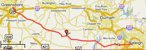
This is a nice rolling route through the rural Piedmont region. From Snow Camp to Green Level it covers the same territory as the NCBC 200 brevet, but with a differing route to provide some variation and uses some quieter and perhaps slightly shorter and maybe hillier roads. Since these roads see less traffic, they get less maintenance and may have a few minor surface blemishes.
The start (Greensboro Train Depot) is about 500' higher than the finish (Raleigh Train Depot), so overall the route is downhill. That said there ARE some climbs throughout, especially in the last 25 miles (east of Jordan Lake). Biggest descent: Jack Bennett Rd approaching Lake Jordan. Biggest climb: Highhouse Rd by Bond Park in Cary.
There are few stores on this route, so traffic and roadside litter are both low (outside of Cary-Raleigh). After mile 16, it's almost 40 miles to the next store, so stock up! (There are a couple of stores just a bit off the route but, unless you know where they are, you won't find them.)
Two off-route stores are located at:
- NC-62 at Alamance Ch Rd (1005)
- (Frosty's) Crawford Dairy Rd at Hamlet's Chapel Rd
The Amtrak fare, one-way, is about $ 11.00.
| Greensboro-Raleigh | |||
|---|---|---|---|
| At | Turn | Go | On |
| Greensboro Amtrak on Tryon St | |||
| 0.0 | East | 1.0 | Washington St |
| BR at Pastor Anderson Way TRO Washington St | |||
| 1.0 | BR | 0.6 | McConnell Rd |
| 1.6 | R | 1.9 | Willow Rd. (go under I-40/I-85 Bus.) |
| 3.5 | L | 14.8 | Alamance Ch Rd (1005) go over I-40/I-85 |
| 14.5 | BR at McPherson Clay TRO Alamance Ch (1005) | ||
| 15.6 | Store at NC-62 (last store for 40mi) | ||
| 18.3 | BR | 7.2 | W. Greensboro Chp Hill Rd (1005) |
| 25.5 | - | 1.1 | Sylvan School Rd |
| 26.6 | L | 0.4 | Snow Camp Rd |
| 27.0 | R | 1.6 | Griffin Rd |
| 28.6 | R | 0.8 | Hollman Mill Rd |
| 29.4 | L | 2.9 | Major Hill Rd |
| 32.3 | R | 0.5 | Lindley Mill Rd |
| 32.8 | L | 2.1 | Old Switchboard Rd |
| (Alt route: Castle Rock Farm Rd to NC-87 to Chicken Bridge Rd) | |||
| 34.9 | L | 1.1 | Greenhill Rd |
| 36.0 | R | 5.9 | Russell Rd |
| 38.4 | - | becomes Mount Olive Ch Rd | |
| 41.9 | L | 2.1 | Chicken Bridge Rd (cross the Haw River) |
| 44.0 | R | 2.9 | River Rd |
| 46.9 | R | 0.6 | Hamlet Chp Rd |
| 47.5 | L | 0.7 | Oak Hill Rd |
| 48.2 | L | 0.3 | Mann's Chp Rd |
| 48.5 | R | 3.4 | Andrew's Store Rd ("Shop Quick" Store at 15-501) |
| 51.9 | L | 0.6 | US-15-501 |
| 52.5 | R | 3.2 | Jack Bennett Rd (Traffic Light) Downhill! |
| 55.7 | R | 1.0 | Lystra Rd |
| 56.7 | R | 2.1 | Farrington Rd (1008) Jordan Lake (Traffic Light) |
| 58.8 | L | 2.8 | Martha's Chp Rd |
| 61.6 | R | 0.4 | NC-751 (caution: fast traffic) |
| 62.0 | L | 0.4 | Lewter Shop Rd (Jean's Berry Patch) |
| 62.4 | R | 10.1 | Green Level Rd |
| Cross the American Tobacco Trail | |||
| (Alt route: go straight) | |||
| 67.9 | - | becomes High House (1615) Climb! | |
| 72.5 | L | 4.0 | W. Chatham (1011) |
| 75.4 | - | becomes Hillsborough St at I-40 overpass | |
| 76.5 | BR | 0.9 | Western Blvd |
| 77.4 | L | 0.2 | Powell Dr |
| 77.6 | R | 1.4 | Beryl Rd |
| 79.0 | BL | 0.1 | TRO Beryl Rd |
| 79.1 | R | 2.1 | Hillsborough St (54) past NCSU |
| 81.2 | BR | 0.6 | W. Morgan St |
| 81.8 | R | 0.2 | Boylan St (RR overpass) |
| 82.0 | L | 0.1 | Dupont Circle |
| 82.1 | L | 0.1 | TRO Dupont Circle |
| 82.2 | L | 0.1 | Cabarrus St |
| 82.3 | L | West St | |
| Amtrak Depot | |||


1 comment:
For the reason that the admin of this website is working, no doubt very shortly it will be well-known, due to its quality contents.
온라인경마
토토사이트
Post a Comment