Friday, October 22, 2010
Thursday, April 23, 2009
Bike-Friendly Bills
- NC-SB 12 would “Ban Mobile Phone Use While Driving”
- NC-HB 9 "Ban Texting While Driving"
(passed in the House; now in the Senate...) - NC-SB 219, "Report Bicycle Crashes to Law Enforcement"
would make more car-bike crashes require a police report by lowering the minimum damage from $1000 to $500 for the bicycle. - NC-HB 68 "Prohibited Use of Electronic Devices/Driving"
- NC-SB 334 "Department of Transportation Reforms"
seeks to cut a lot of politics out of transportation spending--a goal of our new guv. - NC-HB 148 and -SB 151 “Congestion Relief/Intermodal Transport Fund”
allows public transit projects to build supporting bike/ped infrastructure. (Thank South Raleigh's Congresswoman Deborah Ross for this one!) - NC-SB 955 "Bicycle Lights at Night"
seeks to require a taillight instead of rear reflector
(Thanks to NCATA's Ed Harrison for identifying and analyzing these Bills)
The North Carolina Active Transportation Alliance (NCATA) is a fairly new statewide advocacy organization working to improve nonmotorized transportation across NC. NCATA's new Spring 2009 newsletter is now available online at www.ncactive.org and has lots of updates on funding sources, advocacy events and general information about the organization. Download the newsletter and pass it along to friends, colleagues, club members, etc. and consider joining the organization to help support outreach and policy work for human-powered transportation (an individual membership is only $15!!!).
Saturday, April 4, 2009
Mr. C's Magpie

Curtis, the bike wrench Buddha from CNC's glory days, is back! and he is building custom frames!
Read about it, and view the snaps, in Branson's article on Research Trailer Park.
I guess Five-oh wasn't Mr. C's cup-o-tea?
Tuesday, March 3, 2009
CLT to RGH
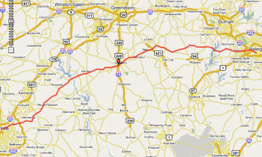
From Charlotte Amtrak to Raleigh Amtrak
This 160mi route takes you from one end of the Amtrak Piedmont's service line to the other. I'm sure a strong and determined cyclist could do it in a single day, but when we rode it a few years ago, we made an overnight camping trip of it, arriving very late at night at the (RV) campground in Asheboro. That is in a "dry" county by the way, so BYOB if needed.Campground staff treated us kindly. We took a dip in the swimming pool. I think there was some all-night industry (timber?) nearby that marred our Zzzzzzs with odor...or noise? or both, I don't recall precisely.
I've heard of one other group planning to do something similar this summer (2009), but they're using a longer route, through the Uwharries and making a three-day (two night) trip of it. Sounds like a lot of fun and adventure!
Maps:
- Raleigh Amtrak Depot [ Google ] [ MapQuest ] [ Yahoo ]
Go to the Bikely / Google Interactive Route Map
| Charlotte Amtrak on N Tryon St | |||
| AT | TURN | GO | ON |
|---|---|---|---|
| 0.0 | R | 3.4 | N Tryon |
| 3.4 | R | 2.6 | Old Concord Rd |
| 6.0 | R | 8.9 | Rocky River Rd |
| 14.9 | R | 0.7 | Lower Rocky River Rd |
| 15.6 | L | 1.5 | Pine Grove Ch Rd |
| 17.1 | L | 8.0 | Flowes Store Rd (becomes Miami Ch Rd) |
| 25.1 | L | 2.2 | Cold Springs Rd |
| 27.3 | R | 0.0 | Cold Springs Rd E |
| 27.3 | L | 2.5 | Walker Rd |
| 29.8 | L | 0.1 | NC-73 (Mt Pleasant Hwy) |
| 29.9 | R | 0.3 | St Johns Ch Rd |
| 30.2 | R | 6.5 | Mt Olive Rd |
| 36.7 | R | 1.3 | Sansbury Rd to Gold Hill |
| 38.0 | L | 3.8 | St Stephens Ch Rd |
| 41.8 | L | 0.1 | Old US-80 |
| 41.9 | R | 0.1 | Doby Dr |
| 42.0 | L | 0.1 | US-52 |
| 42.1 | R | 7.0 | High Rock Rd (becomes Wyatts Grove Ch Rd) |
| 49.1 | R | 8.2 | Bringle Ferry Rd 1002 (becomes Denton Rd) |
| 57.3 | R | 0.9 | W Peacock Ave |
| 58.2 | L | 0.3 | 109 |
| 58.5 | R | 8.8 | E 1st St (becomes Farmer-Denton Rd) |
| 67.3 | L | 8.0 | Old 49 into Asheboro |
| 75.3 | BL | 1.9 | merges with 49 and becomes Albemarle Rd |
| 77.2 | L | 0.4 | S Park St |
| 77.6 | R | 0.8 | Kivett St |
| 78.4 | L | 0.3 | Cliff Rd |
| 78.7 | R | 0.8 | N Randolph (becomes MLK Jr Dr) |
| 79.5 | L | 0.5 | Cedar Falls Rd |
| 80.0 | BR | 4.2 | Old Cedar Falls Rd |
| 84.2 | L | 0.2 | Loflin Pond Rd |
| 84.4 | R | 3.9 | Cedar Falls Rd through Franklinville (becomes NC-22) to Ramseur |
| 88.3 | L | 1.4 | Patterson Grove Rd |
| 89.7 | R | 3.8 | Fuergeson Rd |
| 93.5 | L | 0.7 | NC-49 |
| 94.2 | R | 2.8 | Old Staley Rd (becomes Columbia St in Staley) |
| 97.0 | R | 0.1 | W Railroad St |
| 97.1 | L | 0.2 | Pittsboro St |
| 97.3 | L | 0.2 | Foushee St |
| 97.5 | R | 3.0 | E Franklinville St (becomes Staley-Snow Camp Rd) |
| 100.5 | R | 0.9 | Pike Rd |
| 101.4 | R | 7.9 | Silk Hope Liberty Rd |
| 109.3 | L | 0.5 | Silk Hope Lindley Mill Rd |
| 109.8 | R | 5.7 | Epps Clark Rd (becomes Henderson Tanyard Rd) |
| 115.5 | R | 1.4 | Castle Rock Farm Rd |
| 116.9 | L | 0.7 | NC-87 |
| 117.6 | R | 3.6 | Chicken Bridge Rd (Cross the Haw River) |
| 121.2 | R | 2.8 | River Rd |
| 124.0 | R | 0.6 | Hamlet Chp Rd |
| 124.6 | L | 0.7 | Oak Hill Rd |
| 125.3 | L | 0.3 | Manns Chp Rd |
| 125.6 | R | 3.3 | Andrews Store Rd |
| 128.9 | L | 0.7 | NC-15-501 |
| 129.6 | R | 3.2 | Jack Bennett Rd |
| 132.8 | R | 1.0 | Lystra Rd-Jack Bennett Rd |
| 133.8 | R | 2.1 | Farrington Rd |
| 135.9 | L | 2.9 | Marthas Chp Rd |
| 138.8 | R | 0.4 | NC-751 |
| 139.2 | L | 4.2 | Lewter Shop Rd (becomes Green Level Ch Rd) |
| 143.4 | L | 2.0 | Green Hope School Rd (Walk around barricades and across RR track) |
| 145.4 | R | 1.2 | Carpenter Upchurch Rd |
| 146.6 | L | 3.5 | High House Rd (Cary) |
| 150.1 | L | 0.7 | Old Apex Rd |
| 150.8 | BL | 3.7 | W. Chatham St (becomes E Chatham St) (becomes Hillsborogh St) |
| 154.5 | BR | 0.8 | Western Blvd |
| 155.3 | L | 0.2 | Powell Dr |
| 155.5 | R | 1.5 | Beryl Rd |
| 157.0 | R | 2.2 | Hillsborough St |
| 159.2 | BR | 0.5 | Morgan St |
| 159.7 | R | 0.2 | Boylan Ave |
| 159.9 | L | 0.2 | Kinsey St |
| 160.1 | L | 0.2 | Cabarrus St |
| 160.3 | --- | L | Amtrak Station—Raleigh NC |
| Raleigh Amtrak on Cabarrus St | |||
CH = Church
CHP = Chapel
Monday, March 2, 2009
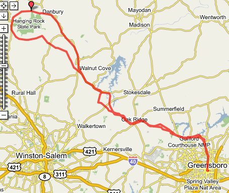
Hanging Rock Loop
Starting point: Greensboro Amtrak Station
Hanging Rock is spectacular. Do this ride as a century or as an overnight camping trip. Here are some snaps from when Roger Truit and I rode it in the Fall of 2006:Bikely Route Map
Starting Point Maps (Greensboro Amtrak Depot):
| 1 Adult Passenger—Rail Fare: $22.00 round-trip Departing: Raleigh, NC (RGH) To Greensboro, NC (GRO) | |||||
|---|---|---|---|---|---|
| Service | Departs | Arrives | Duration | Amenities | Seats/Rooms |
| 73 Piedmont | Raleigh, NC - (RGH) 7:05 am | Greensboro, NC - (GRO) 8:34 am | 1h 29m | Checked baggage | 1 Reserved Coach Seat |
| Returning: Greensboro, NC (GRO) To Raleigh, NC (RGH) | |||||
| Service | Departs | Arrives | Duration | Amenities | Seats/Rooms |
| 74 Piedmont | Greensboro, NC - (GRO) 7:05 pm | Raleigh, NC - (RGH) 8:40 pm | 1h 35m | Checked baggage, Snack car | 1 Reserved Coach Seat |
Cycles de Oro
Greensbro, NC
| Amtrak Station (Greensboro NC) | ||||
| AT | TURN | GO | ON | |
|---|---|---|---|---|
| | 0.0 | Greensboro Amtrak | ||
| 0.0 | W | 0.2 | Washington St (go west) | |
| 0.2 | R | 5.9 | Elm St (alt: Church St) | |
| 6.1 | - | 0.5 | through roundabout onto Bass Chappel Rd | |
| 6.6 | L | 2.5 | Regent's Park Ln (a neighborhood street) | |
| 9.1 | L | 0.5 | Lake Brandt Rd | |
| 9.6 | R | 1.3 | Old Battleground (2340) | |
| 10.9 | - | 0.7 | becomes Horse Pen Creek Rd | |
| 11.6 | R | 1.8 | Carlson Dairy Rd (Greensboro CC) | |
| 13.4 | L | 0.3 | Pleasant Ridge Rd (store) BR TRO Pleasant Ridge Rd (NOT Lewiston) | |
| 13.7 | R | 1.1 | Stanley Huff Rd | |
| 14.8 | L | 3.4 | Bunch Rd | |
| 18.2 | L | 1.5 | Oak Ridge Rd (NC-150) Cross NC-68; Wendy's, Supermarkets, etc. | |
| 19.7 | R | 2.1 | Linville Rd | |
| 21.8 | L | 0.2 | Haw River Rd | |
| 22.0 | R | 2.6 | Goodwill Ch Rd (Guilford) becomes Freeman Rd | |
| 24.6 | L | 0.1 | Piney Grove Rd | |
| 24.7 | R | 2.1 | Goodwill Ch Rd (Forsyth) | |
| 26.8 | R | 1.7 | Belews Creek Rd | |
| 28.5 | L | 5.1 | NC-65 | |
| 33.6 | R | 0.0 | Stokesburg Rd Cross RR Tracks | |
| 33.6 | R | 0.5 | Main St (NC-89/US-311) Walnut Cove Restaurants, ABC Store | |
| 34.1 | L | 6.5 | 3rd St (Walnut Cove) BR becomes Piney Mountain Rd | |
| 40.6 | R | 0.6 | NC-8 | |
| 41.2 | L | 1.0 | Flat Shoals Rd (S. Stokes VFD) | |
| 42.2 | R | 0.9 | TRO Flat Shoals Rd | |
| 43.1 | BL | 4.5 | TRO Flat Shoals Rd (Scenic view of Hanging Rock on the right) | |
| 47.6 | BR | 0.5 | (2nd) Covington Rd 2008 | |
| 48.1 | BR | 0.8 | Capella School Rd | |
| 48.9 | BR | . | NC-66 climb through the pass between HR and Sauratown. Convenience store | |
| At 49.4 you could turn left onto the very scenic Taylor Rd for bonus miles or to climb Sauratown | ||||
| 50.0 | R | 5.3 | Moore's Spring Rd | |
| 55.3 | R | - | Hanging Rock SP Rd. IF going up! | |
| 55.3 | R | 1.6 | Moore's Spring Rd East, toward Danbury | |
| 56.9 | R | 5.0 | NC-8/NC-89 | |
| 61.9 | BL | 6.9 | TRO NC-89 (NOT 8) joins US-311 then becomes Main St in Walnut Cove | |
| 68.8 | L | 0.0 | Stokesburg Rd Cross RR Tracks | |
| 68.8 | L | 5.1 | NC-65 | |
| 73.9 | L | 0.4 | Belews Creek Rd TRO NC-65 | |
| 74.3 | R | 0.8 | TRO Belews Creek Rd / NC-65 | |
| 75.1 | R | 1.7 | Kernersville Rd | |
| 76.8 | R | 1.0 | becomes Piney Grove Rd | |
| 77.8 | L | 2.6 | Freeman Rd becomes Goodwill Ch Rd | |
| 80.4 | L | 0.2 | Haw River Rd | |
| 80.6 | R | 2.1 | Linville Rd | |
| 82.7 | L | 1.7 | Oak Ridge Rd (NC-150) | |
| 84.4 | R | 0.7 | Bunch Rd | |
| 85.1 | BR | 2.7 | TRO Bunch Rd | |
| 87.8 | R | 1.1 | Stanley Huff Rd | |
| 88.9 | L | 0.3 | Pleasant Ridge Rd (Store) | |
| 89.3 | R | 1.8 | Carlson Dairy Rd (NOT Lewiston) (Greensboro CC) | |
| 91.1 | L | 0.7 | Horse Pen Creek Rd | |
| 91.8 | - | 1.3 | becomes Old Battleground (2340) | |
| 93.1 | L | 0.5 | Lake Brandt Rd | |
| 93.7 | R | 1.4 | Regent's Park Ln | |
| 95.1 | R | 0.7 | Bluff Run Dr | |
| 95.8 | L | 0.3 | Lake Jeanette Rd | |
| 96.1 | R | 5.9 | (through roundabout) Elm St (alt: Church St) | |
| 102.0 | L | 0.2 | Washington St | |
| 102.2 | R | 0.0 | Greensboro Amtrak | |
GRO to RGH
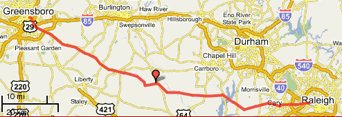
From Greensboro Amtrak to Raleigh Amtrak
Maps:
- Greensboro Depot [ Google ] [ MapQuest ] [ Yahoo ]
- Raleigh Depot [ Google ] [ MapQuest ] [ Yahoo ]
82mi (133km)
This is a nice rolling route through the rural Piedmont region. From Snow Camp to Green Level it covers the same territory as the NCBC 200 brevet, but with a differing route to provide some variation and uses some quieter and perhaps slightly shorter and maybe hillier roads. Since these roads see less traffic, they get less maintenance and may have a few minor surface blemishes.
The start (Greensboro Train Depot) is about 500' higher than the finish (Raleigh Train Depot), so overall the route is downhill. That said there ARE some climbs throughout, especially in the last 25 miles (east of Jordan Lake). Biggest descent: Jack Bennett Rd approaching Lake Jordan. Biggest climb: Highhouse Rd by Bond Park in Cary.
There are few stores on this route, so traffic and roadside litter are both low (outside of Cary-Raleigh). After mile 16, it's almost 40 miles to the next store, so stock up! (There are a couple of stores just a bit off the route but, unless you know where they are, you won't find them.)
Two off-route stores are located at:
- NC-62 at Alamance Ch Rd (1005)
- (Frosty's) Crawford Dairy Rd at Hamlet's Chapel Rd
The Amtrak fare, one-way, is about $ 11.00.
| Greensboro-Raleigh | |||
|---|---|---|---|
| At | Turn | Go | On |
| Greensboro Amtrak on Tryon St | |||
| 0.0 | East | 1.0 | Washington St |
| BR at Pastor Anderson Way TRO Washington St | |||
| 1.0 | BR | 0.6 | McConnell Rd |
| 1.6 | R | 1.9 | Willow Rd. (go under I-40/I-85 Bus.) |
| 3.5 | L | 14.8 | Alamance Ch Rd (1005) go over I-40/I-85 |
| 14.5 | BR at McPherson Clay TRO Alamance Ch (1005) | ||
| 15.6 | Store at NC-62 (last store for 40mi) | ||
| 18.3 | BR | 7.2 | W. Greensboro Chp Hill Rd (1005) |
| 25.5 | - | 1.1 | Sylvan School Rd |
| 26.6 | L | 0.4 | Snow Camp Rd |
| 27.0 | R | 1.6 | Griffin Rd |
| 28.6 | R | 0.8 | Hollman Mill Rd |
| 29.4 | L | 2.9 | Major Hill Rd |
| 32.3 | R | 0.5 | Lindley Mill Rd |
| 32.8 | L | 2.1 | Old Switchboard Rd |
| (Alt route: Castle Rock Farm Rd to NC-87 to Chicken Bridge Rd) | |||
| 34.9 | L | 1.1 | Greenhill Rd |
| 36.0 | R | 5.9 | Russell Rd |
| 38.4 | - | becomes Mount Olive Ch Rd | |
| 41.9 | L | 2.1 | Chicken Bridge Rd (cross the Haw River) |
| 44.0 | R | 2.9 | River Rd |
| 46.9 | R | 0.6 | Hamlet Chp Rd |
| 47.5 | L | 0.7 | Oak Hill Rd |
| 48.2 | L | 0.3 | Mann's Chp Rd |
| 48.5 | R | 3.4 | Andrew's Store Rd ("Shop Quick" Store at 15-501) |
| 51.9 | L | 0.6 | US-15-501 |
| 52.5 | R | 3.2 | Jack Bennett Rd (Traffic Light) Downhill! |
| 55.7 | R | 1.0 | Lystra Rd |
| 56.7 | R | 2.1 | Farrington Rd (1008) Jordan Lake (Traffic Light) |
| 58.8 | L | 2.8 | Martha's Chp Rd |
| 61.6 | R | 0.4 | NC-751 (caution: fast traffic) |
| 62.0 | L | 0.4 | Lewter Shop Rd (Jean's Berry Patch) |
| 62.4 | R | 10.1 | Green Level Rd |
| Cross the American Tobacco Trail | |||
| (Alt route: go straight) | |||
| 67.9 | - | becomes High House (1615) Climb! | |
| 72.5 | L | 4.0 | W. Chatham (1011) |
| 75.4 | - | becomes Hillsborough St at I-40 overpass | |
| 76.5 | BR | 0.9 | Western Blvd |
| 77.4 | L | 0.2 | Powell Dr |
| 77.6 | R | 1.4 | Beryl Rd |
| 79.0 | BL | 0.1 | TRO Beryl Rd |
| 79.1 | R | 2.1 | Hillsborough St (54) past NCSU |
| 81.2 | BR | 0.6 | W. Morgan St |
| 81.8 | R | 0.2 | Boylan St (RR overpass) |
| 82.0 | L | 0.1 | Dupont Circle |
| 82.1 | L | 0.1 | TRO Dupont Circle |
| 82.2 | L | 0.1 | Cabarrus St |
| 82.3 | L | West St | |
| Amtrak Depot | |||


![See in fullscreen [Press F11] Fullscreen](http://btemplates.googlepages.com/fullscreen.gif)