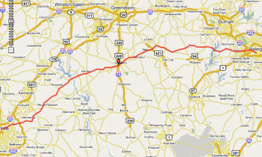
From Charlotte Amtrak to Raleigh Amtrak
This 160mi route takes you from one end of the Amtrak Piedmont's service line to the other. I'm sure a strong and determined cyclist could do it in a single day, but when we rode it a few years ago, we made an overnight camping trip of it, arriving very late at night at the (RV) campground in Asheboro. That is in a "dry" county by the way, so BYOB if needed.Campground staff treated us kindly. We took a dip in the swimming pool. I think there was some all-night industry (timber?) nearby that marred our Zzzzzzs with odor...or noise? or both, I don't recall precisely.
I've heard of one other group planning to do something similar this summer (2009), but they're using a longer route, through the Uwharries and making a three-day (two night) trip of it. Sounds like a lot of fun and adventure!
Maps:
- Raleigh Amtrak Depot [ Google ] [ MapQuest ] [ Yahoo ]
Go to the Bikely / Google Interactive Route Map
| Charlotte Amtrak on N Tryon St | |||
| AT | TURN | GO | ON |
|---|---|---|---|
| 0.0 | R | 3.4 | N Tryon |
| 3.4 | R | 2.6 | Old Concord Rd |
| 6.0 | R | 8.9 | Rocky River Rd |
| 14.9 | R | 0.7 | Lower Rocky River Rd |
| 15.6 | L | 1.5 | Pine Grove Ch Rd |
| 17.1 | L | 8.0 | Flowes Store Rd (becomes Miami Ch Rd) |
| 25.1 | L | 2.2 | Cold Springs Rd |
| 27.3 | R | 0.0 | Cold Springs Rd E |
| 27.3 | L | 2.5 | Walker Rd |
| 29.8 | L | 0.1 | NC-73 (Mt Pleasant Hwy) |
| 29.9 | R | 0.3 | St Johns Ch Rd |
| 30.2 | R | 6.5 | Mt Olive Rd |
| 36.7 | R | 1.3 | Sansbury Rd to Gold Hill |
| 38.0 | L | 3.8 | St Stephens Ch Rd |
| 41.8 | L | 0.1 | Old US-80 |
| 41.9 | R | 0.1 | Doby Dr |
| 42.0 | L | 0.1 | US-52 |
| 42.1 | R | 7.0 | High Rock Rd (becomes Wyatts Grove Ch Rd) |
| 49.1 | R | 8.2 | Bringle Ferry Rd 1002 (becomes Denton Rd) |
| 57.3 | R | 0.9 | W Peacock Ave |
| 58.2 | L | 0.3 | 109 |
| 58.5 | R | 8.8 | E 1st St (becomes Farmer-Denton Rd) |
| 67.3 | L | 8.0 | Old 49 into Asheboro |
| 75.3 | BL | 1.9 | merges with 49 and becomes Albemarle Rd |
| 77.2 | L | 0.4 | S Park St |
| 77.6 | R | 0.8 | Kivett St |
| 78.4 | L | 0.3 | Cliff Rd |
| 78.7 | R | 0.8 | N Randolph (becomes MLK Jr Dr) |
| 79.5 | L | 0.5 | Cedar Falls Rd |
| 80.0 | BR | 4.2 | Old Cedar Falls Rd |
| 84.2 | L | 0.2 | Loflin Pond Rd |
| 84.4 | R | 3.9 | Cedar Falls Rd through Franklinville (becomes NC-22) to Ramseur |
| 88.3 | L | 1.4 | Patterson Grove Rd |
| 89.7 | R | 3.8 | Fuergeson Rd |
| 93.5 | L | 0.7 | NC-49 |
| 94.2 | R | 2.8 | Old Staley Rd (becomes Columbia St in Staley) |
| 97.0 | R | 0.1 | W Railroad St |
| 97.1 | L | 0.2 | Pittsboro St |
| 97.3 | L | 0.2 | Foushee St |
| 97.5 | R | 3.0 | E Franklinville St (becomes Staley-Snow Camp Rd) |
| 100.5 | R | 0.9 | Pike Rd |
| 101.4 | R | 7.9 | Silk Hope Liberty Rd |
| 109.3 | L | 0.5 | Silk Hope Lindley Mill Rd |
| 109.8 | R | 5.7 | Epps Clark Rd (becomes Henderson Tanyard Rd) |
| 115.5 | R | 1.4 | Castle Rock Farm Rd |
| 116.9 | L | 0.7 | NC-87 |
| 117.6 | R | 3.6 | Chicken Bridge Rd (Cross the Haw River) |
| 121.2 | R | 2.8 | River Rd |
| 124.0 | R | 0.6 | Hamlet Chp Rd |
| 124.6 | L | 0.7 | Oak Hill Rd |
| 125.3 | L | 0.3 | Manns Chp Rd |
| 125.6 | R | 3.3 | Andrews Store Rd |
| 128.9 | L | 0.7 | NC-15-501 |
| 129.6 | R | 3.2 | Jack Bennett Rd |
| 132.8 | R | 1.0 | Lystra Rd-Jack Bennett Rd |
| 133.8 | R | 2.1 | Farrington Rd |
| 135.9 | L | 2.9 | Marthas Chp Rd |
| 138.8 | R | 0.4 | NC-751 |
| 139.2 | L | 4.2 | Lewter Shop Rd (becomes Green Level Ch Rd) |
| 143.4 | L | 2.0 | Green Hope School Rd (Walk around barricades and across RR track) |
| 145.4 | R | 1.2 | Carpenter Upchurch Rd |
| 146.6 | L | 3.5 | High House Rd (Cary) |
| 150.1 | L | 0.7 | Old Apex Rd |
| 150.8 | BL | 3.7 | W. Chatham St (becomes E Chatham St) (becomes Hillsborogh St) |
| 154.5 | BR | 0.8 | Western Blvd |
| 155.3 | L | 0.2 | Powell Dr |
| 155.5 | R | 1.5 | Beryl Rd |
| 157.0 | R | 2.2 | Hillsborough St |
| 159.2 | BR | 0.5 | Morgan St |
| 159.7 | R | 0.2 | Boylan Ave |
| 159.9 | L | 0.2 | Kinsey St |
| 160.1 | L | 0.2 | Cabarrus St |
| 160.3 | --- | L | Amtrak Station—Raleigh NC |
| Raleigh Amtrak on Cabarrus St | |||
CH = Church
CHP = Chapel


No comments:
Post a Comment